River plumes and the mediocre fringing reefs

Although the GBR is far from the coast, river plumes occasionally reach it. They generally carry very low concentrations of sediment because most of the sediment has fallen to the seabed within the first few kilometres of the river mouth. The Mediocre Fringing Reefs are, however, far more frequently covered by river plumes, yet even these reefs receive a very small amount of sediment from the plumes relative to what they see due to resuspension of sediment. For example, Figure 2(top) shows a Burdekin River plume over Horseshoe Bay on Magnetic Island in February 2007. On the day this picture was taken the turbidity of the water (turbidity is similar to cloudiness) was 1 NTU – quite a low reading considering that, in the satellite picture, the water looks dirtier than the blue coloured water over the GBR. The bottom picture of Figure 2 looks similar to the top picture with a region of dirty brown water all along the coast. This picture was taken on October 2006 during the dry season in a period of strong South-Easterly trade winds when the rivers are totally dry. Waves caused by the wind caused resuspension of sediment along the entire coast. The turbidity at Horseshoe Bay on that day was over 10 NTU – ten times what was recorded on the day the flood plume picture was taken (Orpin and Ridd, 2012).
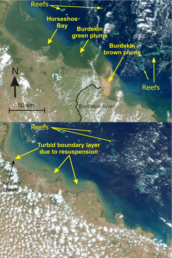
Figure 2
Top. Satellite image of a river plume from the Burdekin River during a flood (see Orpin and Ridd, 2012). The brown area at the river mouth is muddy water. The plume moves to the north-west, clings to the coast, and turns green as the sediment settles out and phytoplankton grows on the nutrients released from the water. The GBR reefs are further offshore, well outside the river plume, but the plume is covering a few small fringing reefs on the islands and coast. Instruments measuring sediment concentrations at Horseshoe Bay on this day showed very low concentrations (less than 1 NTU[*]).
Bottom Satellite image 12 October 2006. This image, taken during a strong wind event during the dry season, clearly shows the turbid coastal boundary region which extends beyond Magnetic Island. Measuring instruments at Horseshoe Bay on this day showed high turbidity (over 10 NTU). This is very typical – strong winds cause waves that suspends the mud near the coast. The suspension by waves is far more important than the river plumes.
It must be remembered that river plumes occur for a few days per year, whereas resuspension events occur for a few days per month, so resuspension is about ten times more important than river plumes for about ten times the duration. In addition, these plumes that are rare events close to shore where the Mediocre Fringing Reefs occur are even rarer and more insignificant for the offshore GBR. Even the foregoing comment above overstates the effect of the river plumes because what has not been considered is the suspension of mud that would have occurred due to the storm that caused the flood shown in Figure 5.1 (Top). This storm caused very large waves that elevated the turbidity to over 60 NTU – 60 times higher than when there were no waves and just a flood plume (Orpin and Ridd, 2012)[1].
There is no doubt that wave resuspension of sediment from the seafloor is the dominant mechanism by which sediments may reach the inshore reefs. It could be questioned, however, if the extra supply of sediment by the rivers means that there is greater availability of bottom sediments that can be suspended by waves. In other words, does the extra sediment indirectly increase the sediment on to the reefs. Larcombe and Woolfe(1998) pointed out that, for most locations, there are such large amounts of fine mud available for suspension, deposited over the last few thousand years, that the small extra amount caused by the increased erosion over the last century is insignificant. For example, for Cleveland Bay, there is up to 10 metres of fine mud on the seabed that originally came from the Burdekin River to the south-east. The top 20 centimetres or so is “bioturbated”, that is, organisms in the sediment churn it up, like worms in garden soil, mixing the top layer and any new sediment that might come from other areas. With ten metres of mud on the seabed, an extra couple of millimetres of post-European mud makes very little difference.
Some scientists have challenged the proposition that rivers are relatively insignificant to the GBR, most notably Fabricius et al. (2013).[2] Fabricius, one of the main proponents of the hypothesis that the GBR is badly damaged by agriculture and climate change, looked at data of sediment concentrations (water turbidity) in the water at some fringing reefs and found that water turbidity was higher at sites close to rivers. This is exactly what would be expected as areas close to rivers will more likely be surrounded by river mud that has been deposited over the last few thousand years and is available for resuspension by waves. It is precisely what Larcombe and Woolfe proposed. Fabricius also showed that there was a small increase in the water turbidity at some of the reefs caused directly by flood plumes and stated
a reduction in the river loads of fine sediments and nutrients through improved land management should lead to measurably improved inner-shelf water clarity in the most turbid parts of the GBR.
Analysis of Fabricius’s data[3] showed a very small increase in turbidity at these “most turbid” or dirty reefs, during flood periods, which for the big rivers of the GBR occur only for about one percent of the time. Even this result was only found for about half of the fringing reefs that they studied, which are part of the one percent of the corals that live on the Mediocre Fringing Reefs. So, despite this work being used to claim that farmers are killing the reef – the opposite was actually demonstrated. Fabricius et al. (2013) showed no effect on the GBR, and only a small effect, for a short period of time, on some of the reefs of the one percent Mediocre Fringing Reefs, that is, effectively nothing. This is what Piers Larcombe and Ken Woolfe had concluded in 1999.[4]
Fabricius, in a different study (Fabricius et al., 2013)[5], found what may be a subtle but genuine effect of rivers on water clarity (photic depth). Using satellite data to measure water clarity, they compared years when there were major floods with years when there were no major floods. They found that the water clarity was reduced for many months afterwards in the years with major floods. The effect is not obvious in the data and somewhat opaque statistical and modelling methods were deployed to demonstrate the influence of the floods.
Interestingly the effect they measured was only significant in the middle of the lagoon between the coast and the GBR where there is very little coral. They measured almost no reduction in photic depth for the GBR itself, or for the coastal areas where the greatest problem would be expected. This work needs to be investigated further because if it is correct, a small but significant reduction in water clarity, and therefore light availability for some of the coral reefs, has been demonstrated. This would be an important result and the only measurement, indirect as it is, showing a reduction in the water quality of the GBR.
The Fabricius et al. (2013) paper has been peer reviewed, but this is no guarantee of correctness (see section on quality assurance of science). Given its potential significance, therefore, more investigation checking and replication of this work is essential. In contrast, observations about the importance of resuspension of mud on the seabed by waves, or the almost total lack of mud on the GBR, have been replicated many times by different workers, including Fabricius.[6],[7]
[*] NTU is a unit of turbidity or water cloudiness. High sediment concentrations increase turbidity. In conditions with strong waves, turbidity can easily exceed 100 NTU close inshore.
[1] Orpin, Alan R., Ridd, Peter V., 2012. Exposure of inshore corals to suspended sediments
due to wave-resuspension and river plumes in the central Great Barrier Reef: a reappraisal.
Cont. Shelf Res. 47, 55–67.
[2] Fabricius, K.E., De’ath, G., Humphrey, C., Zagorskis, I. and Schaffelke, B. (2013). Intra-annual variation in turbidity in response to terrestrial runoff on near-shore coral reefs of the Great Barrier Reef. Estuarine, Coastal and Shelf Science, 116, pp.57–65.
[3] Larcombe, P. and Ridd, P. (2019). Viewpoint: The need for a formalised system of Quality Assurance for Environmental Policy-Science and for improved policy advice to Government on the Great Barrier Reef. Reply to – “Support for improved quality control but misplaced criticism of GBR science” by Britta Schaffelke, Katharina Fabricius, Frederieke Kroon, Jon Brodie, Glenn De’ath, Roger Shaw, Diane Tarte, Michael Warne, Peter Thorburn (Marine Pollution Bulletin 129: 357–363, 2018). Marine Pollution Bulletin, 143, pp.50–57.
[4] Larcombe, P. and Woolfe, K.J. (1999). Increased sediment supply to the Great Barrier Reef will not increase sediment accumulation at most coral reefs. Coral Reefs, 18(2), pp.163–169.
[5] Fabricius, K.E., Logan, M., Weeks, S. and Brodie, J. (2014). The effects of river run-off on water clarity across the central Great Barrier Reef. Marine Pollution Bulletin, 84(1–2), pp.191–200.
[6] Fabricius, K.E., De’ath, G., Humphrey, C., Zagorskis, I. and Schaffelke, B. (2013). Intra-annual variation in turbidity in response to terrestrial runoff on near-shore coral reefs of the Great Barrier Reef. Estuarine, Coastal and Shelf Science, 116, pp.57–65.
[7] Hopley, D., Smithers, S.G. and Parnell, K.E. (2007). The geomorphology of the Great Barrier Reef : development, diversity, and change. Cambridge: Cambridge University Press.
